Google ME-POIs Beats Gemini Embeddings at Place Analysis
Google Research has introduced ME-POIs, a framework combining text embeddings with anonymized mobility data to vastly improve how AI models understand real-world locations.
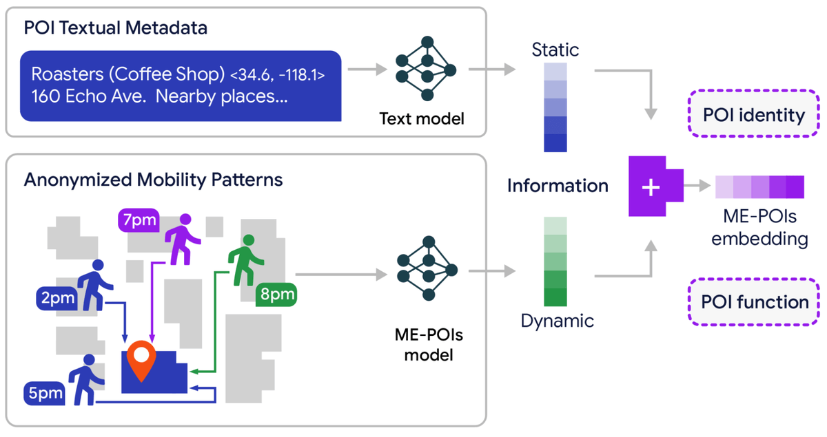
Google Research has introduced Mobility-Embedded POIs, or ME-POIs, a new framework designed to bridge the gap between static business metadata and real-world activity. By combining standard text embeddings with anonymized, aggregated mobility patterns, the system helps language models understand the temporal rhythms of physical locations. In testing, the ME-POIs framework achieved an 81.9 percent relative gain in predicting visit intent, a 75.1 percent improvement in price-level classification, and a 24.7 percent increase in busyness estimation accuracy compared to baseline models.
The architecture relies on a three-step pipeline to transform raw location data into dense embeddings. First, visit alignment maps aggregate arrival times, departure trends, and stay durations over a one-year cycle. Second, spatial multiscale visit propagation addresses data sparsity by transferring aggregated visit patterns from busy, data-rich neighboring locations to nearby places with sparse data. Finally, text-mobility synergy aligns high-level language embeddings, such as Gemini embeddings, with these mobility vectors by maximizing their cosine similarity.
Researchers evaluated the framework in Los Angeles and Houston across five downstream tasks: price-level classification, permanent closure detection, visit intent classification, busyness forecasting, and operating hours estimation. ME-POIs was tested against baselines including Gemini embeddings, TrajGPT, and various hybrid models. Notably, the researchers found that models trained solely on mobility data outperformed text-only language models in several tasks, including price-level classification, proving that physical visit patterns can be highly descriptive.
For AI practitioners building geospatial applications, this development demonstrates that relying solely on text-based location metadata leaves significant signal on the table. By integrating aggregated mobility patterns without compromising individual privacy, developers can build more accurate mapping and search features. The framework allows downstream classifiers to leverage these rich, hybrid signatures without needing to recompute complex spatial and temporal attributes from scratch.
This is our own summary of reporting by AlphaSignal


%22%3E%0A%3Cstop%20offset%3D%220%25%22%20stop-color%3D%22%231a1c1c%22%2F%3E%3Cstop%20offset%3D%22100%25%22%20stop-color%3D%22%234c4546%22%2F%3E%0A%3C%2FlinearGradient%3E%3C%2Fdefs%3E%0A%3Crect%20width%3D%22800%22%20height%3D%22500%22%20fill%3D%22url(%23g)%22%2F%3E%0A%3Cg%20stroke%3D%22%23ffffff%22%20stroke-opacity%3D%220.10%22%20stroke-width%3D%222%22%3E%0A%3Cline%20x1%3D%22-200%22%20y1%3D%22500%22%20x2%3D%22100%22%20y2%3D%220%22%2F%3E%3Cline%20x1%3D%22-60%22%20y1%3D%22500%22%20x2%3D%22240%22%20y2%3D%220%22%2F%3E%3Cline%20x1%3D%2280%22%20y1%3D%22500%22%20x2%3D%22380%22%20y2%3D%220%22%2F%3E%3Cline%20x1%3D%22220%22%20y1%3D%22500%22%20x2%3D%22520%22%20y2%3D%220%22%2F%3E%3Cline%20x1%3D%22360%22%20y1%3D%22500%22%20x2%3D%22660%22%20y2%3D%220%22%2F%3E%3Cline%20x1%3D%22500%22%20y1%3D%22500%22%20x2%3D%22800%22%20y2%3D%220%22%2F%3E%3Cline%20x1%3D%22640%22%20y1%3D%22500%22%20x2%3D%22940%22%20y2%3D%220%22%2F%3E%3Cline%20x1%3D%22780%22%20y1%3D%22500%22%20x2%3D%221080%22%20y2%3D%220%22%2F%3E%0A%3C%2Fg%3E%0A%3Ctext%20x%3D%2248%22%20y%3D%22430%22%20font-family%3D%22Helvetica%2CArial%2Csans-serif%22%20font-size%3D%22132%22%20font-weight%3D%22800%22%0A%20fill%3D%22%23ffffff%22%20fill-opacity%3D%220.22%22%20letter-spacing%3D%22-4%22%3ETD%3C%2Ftext%3E%0A%3C%2Fsvg%3E)
